Kenai Fjords National Park
Kenai Fjords National Park was designated as a national monument in 1978 and as a national park in 1980. The centerpiece of the park is 300,000-plus acre, 1,000 foot-deep Harding Icefield – a relic of the most recent ice age and what most of North America once looked like not really all that long ago. This giant icefield spawns 38 glaciers, and is the driving force behind the rest of the park’s geology and climate. As the ice has retreated over the years, sea water has filled in the valleys carved by glaciers to form fjords, and a temperate rainforest climate has developed in melted out areas, making for one of the most mystical feeling places in North America.
Despite these changes and quickly retreating glaciers, as you can tell by its current size, a lot of ice still remains in the Harding Icefield! The only accessible portion of the icefield by road is Exit Glacier, where visitors to the national park can take a short jaunt to a view of the toe of the glacier, or take the epic Harding Icefield Trail, which skirts Exit Glacier and climbs to an endless vista of ice that buries everything but the very peaks of mountains.
The Harding Icefield Trail is 8.2 miles roundtrip and gains 3,800 feet in elevation – that’s a rate of about 1,000 feet per mile! We were initially a little intimidated by these numbers, but the trail sounded too amazing not to try. Combine that with the easy accessibility from the town of Seward, and it was a no-brainer.
The only caveat was that we’d heard that the views were much more impressive on a clear day – somewhat of a rarity given that the Seward area, being on the water and surrounded by a huge, weather creating icefield, is more often overcast and drizzly than not. Our friend, Rob, was slated to come out during our time on the Kenai Peninsula, and lucky for him, the sunniest, clearest looking day happened to be the same day he was flying into Anchorage at 1am….he was a trooper about it though!
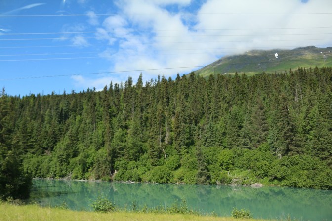
The Stunning Seward Highway
After a late night, we left our base at the Alyeska Resort in Girdwood mid-morning and made the gorgeous two hour drive down the Seward Highway. This kind of scenery is what RVing in Alaska is all about…


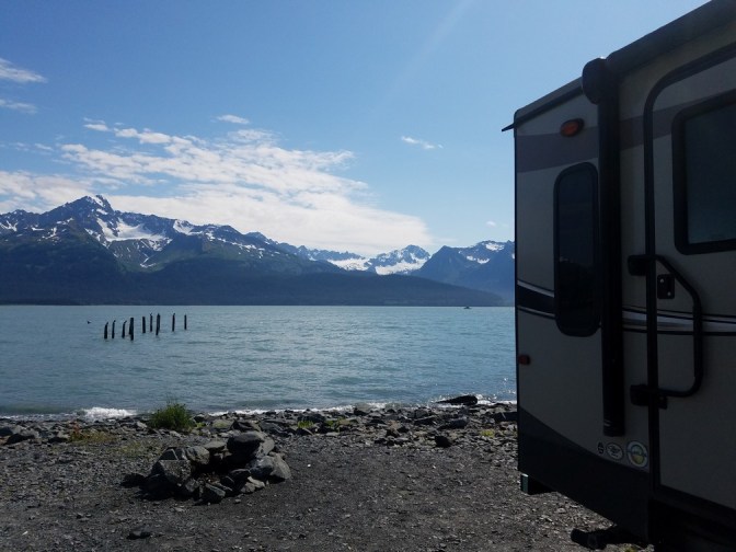
At our destination, we were greeted by promisingly sunny skies and landed a primo waterfront spot in Seward’s Waterfront Park. The entire waterfront in Seward is a designated public campground as the massive 1964 earthquake that caused the shoreline to basically break off into the sea has made them hesitant to build right on the water again. While we definitely wouldn’t want to be there in another quake, this had to have been one of the best sites we’ve ever had in a campground. The spots were tight, but with these views and own our waterfront property, we couldn’t have cared less…
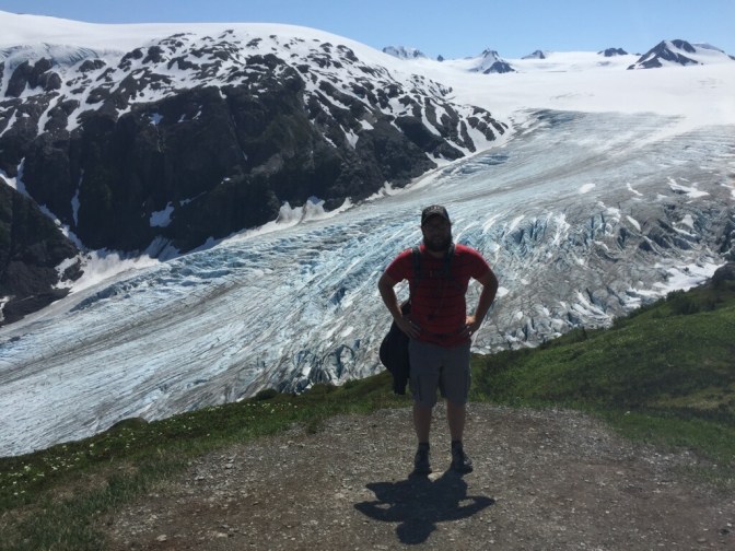
Exit Glacier and the Harding Icefield
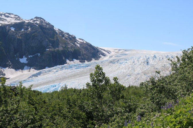
We quickly set up and drove the 20 minutes up to the parking for Exit Glacier, getting sneak peeks at the glacier itself as we drove in and got one of the last parking spots. The weather looked to be absolutely perfect as we started the trail. We were so psyched for this hike!
The trail started out with the first mile or two in the woods. It was a little buggy but we found the trail to be sturdy footing and really well defined and maintained – definitely moreso than any other trail we encountered in Alaska (I’m not even sure they consider it to be a real Alaskan hike if you don’t have to bushwhack, route find, or get your feet wet). There were rock stairs carved in a good part of it, which helped make the elevation gain a lot easier, in our opinion. The trail was crowded but the weather had everyone in such a good mood, it almost made it that much more fun to be exchanging pleasantries with everyone we passed. The weather was clearly a little hot for the wildlife though – we caught a black bear rolling around on a patch of snow just to cool off! (Sadly, he moved too quick for a picture…)


As we rose above treeline, Exit Glacier started to come into view, as well as peeks at the icefield itself and views of the valley we were leaving way down below.


The path eventually turned to a flatter, but still steep incline without the rocky terrain to help it move along. The elevation gain had been pretty relentless up until now, but this is where we probably felt it the most! Short breaks kept it pretty manageable though and the footing continued to be pretty packed down and sturdy.
For the last mile and a half, we were met with wide patches of snow. You’d think on a trail this steep, we’d be sliding around a good bit; but on a warm early July day, we found it just the right amount of crunchy and not too hard packed or slushy to be a pretty pleasant jaunt and a welcome way to cool off a bit. Plus, the trail really seemed to level off a bit towards the end and the snow just added to the beauty of the breathtaking surroundings.

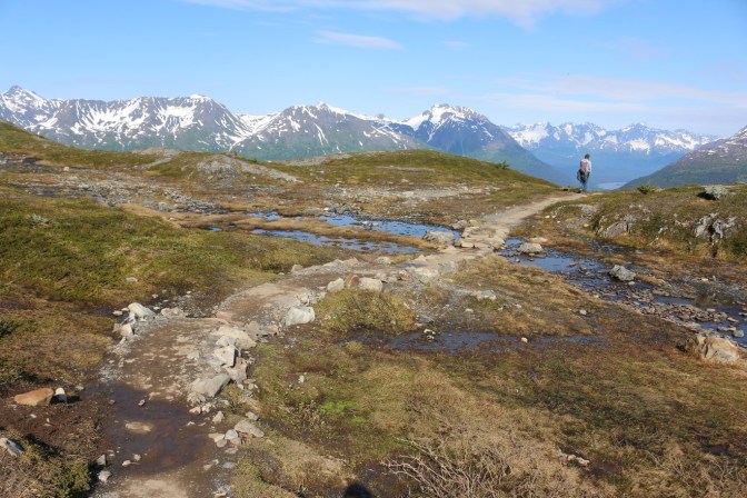


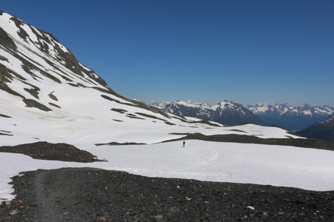

Once we passed the emergency shelter, 0.3 miles later, we felt like we had reached the top of the world. While we had been able to see part of the view on the latter part of the trail, the views up top seemed to be endless. It was mind boggling to think that whole mountains were buried under that ice and that it stretched practically as far as the eye could see! We still couldn’t get over how lucky we’d gotten with the weather, either – literally only one small cloud in the sky. The odds of this in rainy, coastal Alaskan towns are probably about comparable to seeing Denali all the way out!


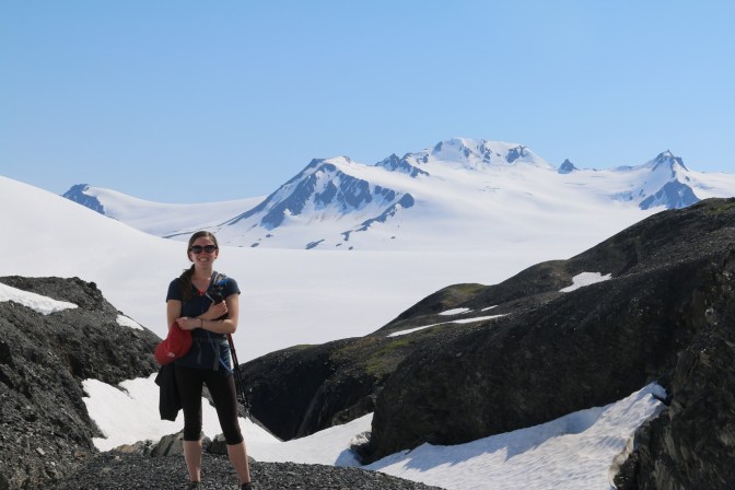

The official end of the trail is debatable as it dumps out onto a large rock outcropping where it is easy to go explore a little. It’s not recommended to go out onto the ice itself from here, as it is a volatile, potentially deadly environment in summer. Chunks of hard, dense ice can break off without warning and remaining soft snow hides deep crevasses. It is awesome though that the rocky area is large enough that you can really carve out your own spot for lunch or photos despite the crowds. We must have spent an hour up here, just taking it all in…
The incredible views of the top half of the trail kept us engaged as we steadily made our way back down. The wooded part of the trail started to drag towards the end, but all in all, we felt more invigorated than tired by the end of the trail (though our temporary jelly-legs might have argued differently). It really was an accessible trail, proven by the fact that we saw people of all ages and fitness levels finishing it in a reasonable amount of time. All in, it probably took us just under 6 hours with navigating crowds and really taking our time to take it all in.
We headed back to our amazing campsite in Seward, still enjoying the perfect weather and feeling on top of the world…


It truly was breathtaking!!
LikeLike
Thank you for checking us out! It certainly was! 🙂
LikeLike
Thank you! It certainly was!
LikeLike
Wow! Just… wow.
LikeLiked by 1 person
Absolutely beautiful. Looks like a lot of fun!
LikeLiked by 2 people
pretty landscape
LikeLiked by 2 people